Interesting Surface Pressure Maps
by Ronald B. Standler
The maps are works of the U.S. Government, and are therefore not protected
by copyright. 17 U.S.C. §105.
Table of Contents
Introduction
Hurricane Sandy 29 Oct 2012
Nor'easter 9 Feb 2013
18 Nov 2013
24 Nov 2013
11 Jan 2014
24 Apr 2014
17 Sep 2015 (calm wind)
24 Feb 2016
30 Oct 2017
4 Jan 2018
Thunderstorms
Introduction
When I was a child, about 9 y old, I knew that air pressure was
lower at high elevations (e.g., on a mountain) than at sea level.
So I was perplexed in looking at air pressure maps and seeing
no effect by the Rocky Mountains in New Mexico and Colorado.
What science textbooks did not make clear was that the air pressure
map shows data that have been modified to remove the effect of altitude,
so that the land is effectively all at sea level elevation. This modification lets
meteorologists clearly see weather systems, without the complication of
varying altitude.
Later in life, I noticed that textbook authors and professors often
neglect to explain all of the assumptions and limitations,
because "everyone knows that" or "it is obvious". As students know,
it is not obvious.
Meteorologists measure air pressure in millibars.
One millibar is equivalent to 100 Newtons per square meter (equivalent
to 100 Pascals). Some meteorologists say "hecto-Pascal" (hPa) instead
of "millibar", but the two units are equivalent.
A surface pressure map shows a plot of lines of equal surface pressure, called
isobars. Convention is to space the isobars four millibars apart, so
one can easily compare maps for different times.
Standard sea level pressure is 1013.25 mb. While a barometer filled
with mercury typically has a scale in millimeters of mercury, meteorologists
convert that measurement to millibars.
On a typical day, the surface pressure map shows a range of pressures
from about 1000 mb to 1020 mb. As a general rule, regions of strong
high pressure (i.e., more than approximately 1025 mb) are associated with clear
skies. Regions of low pressure (i.e., less than approximately 1000 mb) are
associated with clouds, and sometimes rain or snow.
The farther the pressure sinks below 1013 mb, the more intense the storm.
In particular, one measure of hurricane intensity is the minimum surface
air pressure in the eye of the hurricane.
The center of a region of low pressure is marked with an L (for low)
on a surface pressure map. Note that such L-regions are relative to
pressure at surrounding locations.
The center of an L-region could have a pressure of
1015 mb (i.e., higher than standard sea-level pressure) if the pressure
at surrounding locations is higher than 1015 mb.
When isobars are crowded together, the wind speed is intense, owing
to the pressure gradient. The maps shown below contain examples of such
large pressure gradients.
Finally, in the Northern Hemisphere, winds rotate clockwise (when viewed from above)
around a high-pressure system, and winds rotate counterclockwise around a low-pressure
system. Wind blows from high-pressure regions to low-pressure regions, but
the rotation of the Earth (i.e., Coriolis force) makes the wind rotate.
For that reason, winds are approximately parallel to isobars on the surface
pressure map.
Hurricane Sandy
29 Oct 2012
 Low pressure of 950 mb in Atlantic Ocean, and 996 mb on coast of Virginia.
The center of the storm hit New Jersey, inflicting immense damage there
and also in New York City.
Low pressure of 950 mb in Atlantic Ocean, and 996 mb on coast of Virginia.
The center of the storm hit New Jersey, inflicting immense damage there
and also in New York City.
Links to scientific reports about Hurricane Sandy:
Nor'easter
9 Feb 2013
 Low pressure of 970 mb in Atlantic Ocean, and 1008 mb on coast of New Hampshire.
This type of storm is known in New England as an "Nor'easter", because
the low pressure to the southeast of New England causes winds to
blow from the Northeast. Such storms are significant because they bring
moist air from the sea over land, and often create heavy rainfall/snowfall.
18 Nov 2013
 Low pressure of 972 mb in Canada, and 1004 mb in lower Michigan.
The high winds associated with this storm interrupted electric power to
a half-million customers in Michigan.
In Concord, NH, the wind from the south brought warm, moist air:
a daily high temperature of +17 celsius
(average high for this date is only +9 celsius)
and 8 mm of rain.
24 Nov 2013
 A low pressure of 965 mb centered over northern Québec province in Canada,
with high pressure of 1040 mb centered over Illinois,
produced an intense pressure gradient in New England.
In Concord, NH, this gradient caused high winds (e.g., gusts of 75 km/h) and
low temperatures (e.g., daily high of -4 celsius on 24 Nov, and
low of -10 celsius in the early morning of 25 Nov —
compared to a 19-year average of +7 and -3 celsius).
More than 40,000 utility customers in New Hampshire lost electric power on
24 Nov because high winds had blown trees into overhead electric wires.
A low pressure of 965 mb centered over northern Québec province in Canada,
with high pressure of 1040 mb centered over Illinois,
produced an intense pressure gradient in New England.
In Concord, NH, this gradient caused high winds (e.g., gusts of 75 km/h) and
low temperatures (e.g., daily high of -4 celsius on 24 Nov, and
low of -10 celsius in the early morning of 25 Nov —
compared to a 19-year average of +7 and -3 celsius).
More than 40,000 utility customers in New Hampshire lost electric power on
24 Nov because high winds had blown trees into overhead electric wires.
NOAA's automated observations at the Concord, NH airport stopped sometime after
13:51 EST on 24 Nov. I used the measurements from the personal weather
station in East Concord on the WeatherUnderground website.
NOAA resumed automated observations at 08:51 on 25 Nov.
11 Jan 2014
 During 7 to 10 Jan 2014, the air temperature at Manchester, NH
was consistently below 0 celsius.
On 11 Jan, a low pressure system of 984 mb was located to the northwest,
which would bring warm air from the south up to New Hampshire
(remember winds rotate counterclockwise around a region of low pressure).
The map for 21:00Z corresponds to 16:00 EST.
During 7 to 10 Jan 2014, the air temperature at Manchester, NH
was consistently below 0 celsius.
On 11 Jan, a low pressure system of 984 mb was located to the northwest,
which would bring warm air from the south up to New Hampshire
(remember winds rotate counterclockwise around a region of low pressure).
The map for 21:00Z corresponds to 16:00 EST.
But there was a stationary front stretching east-west across New Hampshire
during the afternoon. Temperatures north of the front were near zero celsius,
while temperatures south of the front were near +11 celsius.
The front traveled north through Manchester, NH between 14:53 and 15:53 EST
and the temperature there jumped from 1.7 to 11.7 celsius in one hour.
After the front passed to the north, there was a wind from the south with a speed
between 10 to 20 km/h, caused by the pressure gradient from the
low pressure system to the northwest.
The air temperature at Manchester was +11 celsius at midnight on 11 Jan!
A typical midnight temperature in January would be -5 celsius.
On the morning of 12 Jan 2014, the low intensified to 975 mb and
moved northeast, above Maine.
The wind in New Hampshire then shifted to from the west.
24 April 2014
 At 06:00 GMT a 987 mb low pressure region south of Nova Scotia, Canada
and a 1010 mb pressure in Albany, NY created an intense pressure gradient
in New England.
In Concord, NH, the surface pressure was 1003.5 mb,
with wind gusts of 50 km/h.
At 06:00 GMT a 987 mb low pressure region south of Nova Scotia, Canada
and a 1010 mb pressure in Albany, NY created an intense pressure gradient
in New England.
In Concord, NH, the surface pressure was 1003.5 mb,
with wind gusts of 50 km/h.
At 18:00 GMT, the low pressure region moved northeast of the southern tip
of Nova Scotia, and the minimum surface pressure was 984 mb.
The pressure was 1006 mb in Concord, NH, with wind gusts to
70 km/h.
17 Sep 2015
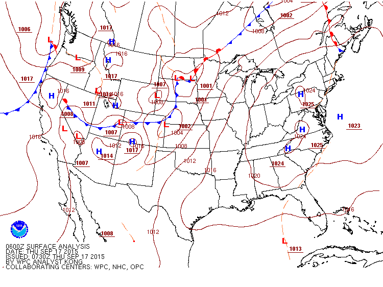 This example shows the surface pressure map for a time when the wind at Concord, NH
was calm from 22:51 GMT on 16 Sep continuously through
14:51 GMT on 17 Sep 2015,
an interval of 16 hours with calm wind. The surface pressure map is
for 06:00 GMT on 17 Sep, approximately in the middle of this period
of calm winds.
You can see the small pressure gradient in the northeastern USA,
which caused the calm wind.
At 05:51 GMT (01:51 EDT) on 17 Sep,
the surface pressure at Concord, NH was 1022.2 mb
and the surface pressure at Albany, NY was 1023.0 mb.
This example shows the surface pressure map for a time when the wind at Concord, NH
was calm from 22:51 GMT on 16 Sep continuously through
14:51 GMT on 17 Sep 2015,
an interval of 16 hours with calm wind. The surface pressure map is
for 06:00 GMT on 17 Sep, approximately in the middle of this period
of calm winds.
You can see the small pressure gradient in the northeastern USA,
which caused the calm wind.
At 05:51 GMT (01:51 EDT) on 17 Sep,
the surface pressure at Concord, NH was 1022.2 mb
and the surface pressure at Albany, NY was 1023.0 mb.
24 Feb 2016
This storm began as a region of low pressure centered on western Tennessee
at 01:00 EST on 24 Feb 2016.
The pressure at the center was a constant 986 or 987 millibars from
04:00 EST on 24 Feb to 04:00 EST on 25 Feb, as the
center moved northeast through Kentucky, Ohio, and New York State.
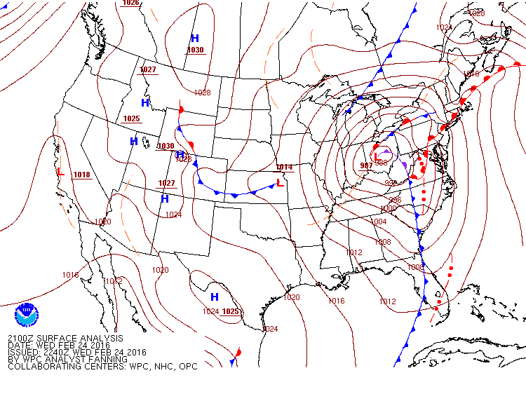
On the map, notice the squall line that travelled east through Virginia and North Carolina.
There is another squall line in Florida.
This storm brought a total of 42 mm of rain to Concord, NH.
As one would expect from the intense pressure gradient, there were high winds
across much of the eastern USA on 24 Feb.
The Associated Press
and Reuters
reported that a total of 8 people died from this storm,
half of them in Virginia. There were tornadoes in Virginia and Pennsylvania.
More than 1100 airplane flights at two airports in Chicago were cancelled.
A maximum of 38 cm of snow fell in northwest Indiana.
Chicago Tribune.
I looked at the National Weather Service websites for various cities and found
the following information for 24 Feb.
Snow with wind gusts up to 79 km/h was recorded at Midway Airport
in Chicago.
Rain with wind gusts up to 69 km/h at Philadelphia airport,
with a total of 48 mm of rain on 24 Feb.
Thunderstorm with wind gusts up to 53 km/h at Reagan Airport in
Washington, DC.
The Washington Post
has a news article that explains some of the meteorology in this storm.
At about 08:30 EST on 25 Feb, a warm front passed north through
Concord, NH. The air temperature jumped from +6 to +14 celsius
in less than one hour. The average high temperature for this day is
+2 celsius, so the high temperature of +17 celsius was unseasonably warm
for Concord, NH.
30 Oct 2017
There was an intense storm with heavy rain and strong winds on 30 Oct 2017
in New England. This storm began with a low-pressure region centered east
of North Carolina on 29 Oct 2017. The low-pressure region quickly moved
northward as shown in the following list:
- 14:00 EDT (18Z) on 29 Oct: 994 mb centered east of North Carolina
- 17:00 EDT (21Z) on 29 Oct: 991 mb centered east of Virginia
- 20:00 EDT on 29 Oct: intensified to 984 mb centered east of Virginia
- 23:00 EDT on 29 Oct: intensified to 977 mb centered on New Jersey
- 02:00 EDT (06Z) on 30 Oct: 975 mb centered on eastern New York State
- 05:00 EDT (09Z) on 30 Oct: 971 mb centered on border of Canada and New York State.
Also a cold front that had been stalled in central New York State for 33 hours
moved to the border of Western Massachusetts.
- 08:00 EDT (12Z) on 30 Oct: 970 mb centered in Canada, cold front moved to Atlantic Ocean.
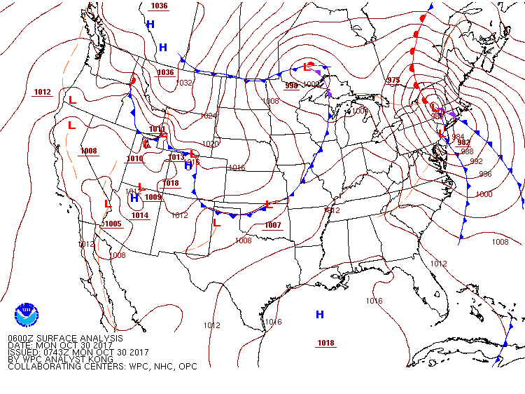 Surface pressure map for 02:00 EDT (06Z) on 30 October 2017.
The weather station at the Manchester, New Hampshire airport recorded wind gusts
as high as 95 km/h at 02:00 EDT on 30 October.
The strong winds blew tree branches into overhead electric power lines, causing
many electric outages. The
Union-Leader
newspaper reported that this storm caused the fourth-largest electric power
outage in New Hampshire history. The
Associated Press
reported that a total of 1.5 million utility customers in the northeastern USA
lost electric power in this storm.
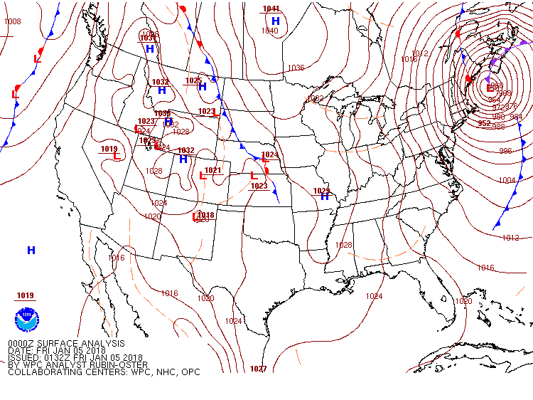
4 Jan 2018
On Tuesday, 2 January 2018, meteorologists predicted that a low-pressure
region would form east of Florida, and then rapidly move north along the coast,
intensifying to 950 mb on Thursday afternoon.
This storm will be essentially a hurricane in January, with snow instead of rain.
Some meteorologists referred to this storm with the hyperbole “bomb cyclone”.
Washington Post.
The National Weather Service surface pressure map for 18:00 GMT (13:00 EST)
on 3 January shows a 1004 mb low-pressure region in the Atlantic Ocean
east of Florida. Three hours later, this low had intensified to 997 mb
and the center moved to east of the Florida/Georgia border. This storm
caused rare snow in Florida and Georgia.
New York Times;
Times-Union in Jacksonville, Florida;
Associated Press.
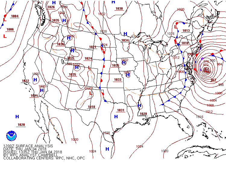 Surface pressure map at dawn (07:00 EST) on 4 January 2018,
showing 957 mb low centered east of Virginia.
Surface pressure map at dawn (07:00 EST) on 4 January 2018,
showing 957 mb low centered east of Virginia.
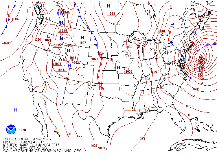 Surface pressure map at 10:00 EST on 4 January 2018,
showing 951 mb low centered east of Maryland. Note that the outer isobars
of this storm now cover all of New England.
Surface pressure map at 10:00 EST on 4 January 2018,
showing 951 mb low centered east of Maryland. Note that the outer isobars
of this storm now cover all of New England.
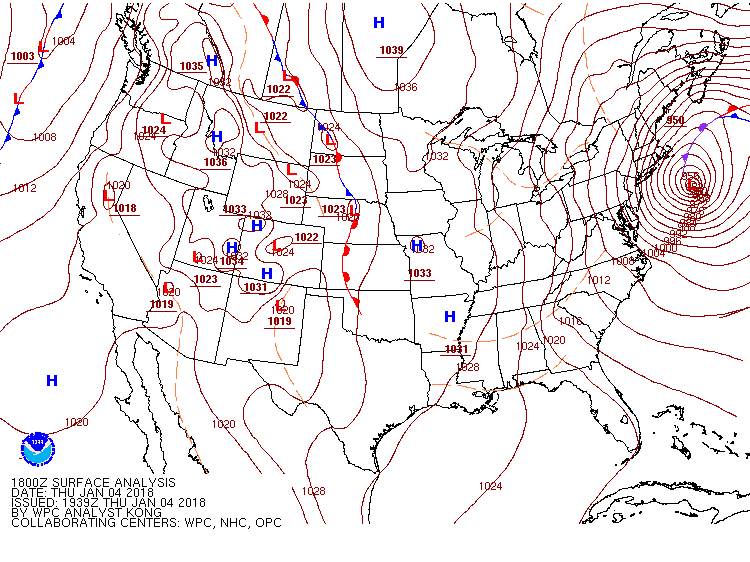 Surface pressure map at 13:00 EST on 4 January 2018,
showing 950 mb low centered east of New Jersey. The biggest impact
from this storm in New England was coastal flooding as 51 km/h wind
gusts combined with an astronomical high tide at 12:48 EST in Portsmouth, NH.
Surface pressure map at 13:00 EST on 4 January 2018,
showing 950 mb low centered east of New Jersey. The biggest impact
from this storm in New England was coastal flooding as 51 km/h wind
gusts combined with an astronomical high tide at 12:48 EST in Portsmouth, NH.
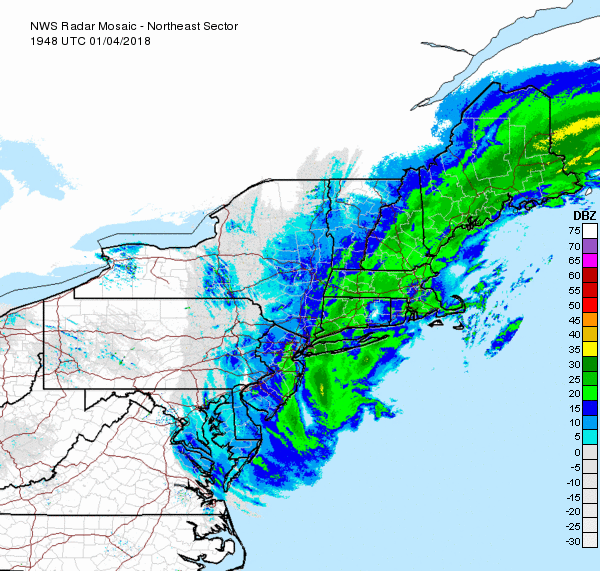 Radar base reflectivity mosaic in Northeastern USA at 14:48 EST on 4 January 2018.
The echoes from this storm are weak (mostly less than 30 dBZ),
as the snow from this storm is dying.
Radar base reflectivity mosaic in Northeastern USA at 14:48 EST on 4 January 2018.
The echoes from this storm are weak (mostly less than 30 dBZ),
as the snow from this storm is dying.
 Surface pressure map at 19:00 EST on 4 January 2018,
showing 952 mb low centered east of Maine. At Concord, NH and
Manchester, NH the wind gusts were as high as 74 km/h.
Surface pressure map at 19:00 EST on 4 January 2018,
showing 952 mb low centered east of Maine. At Concord, NH and
Manchester, NH the wind gusts were as high as 74 km/h.
Concord, NH received a total of 33 cm of snow from this storm.
However, coastal flooding was the major impact in New Hampshire.
Union-Leader.
More on the storm is at the
New York Times; and
Boston Globe.
Thunderstorms
Not all severe weather is associated with concentric isobars on a surface pressure
map.
Isolated thunderstorms can occur when heating by sunlight in the morning
evaporates water from the ground, the water vapor rises with the warm air,
until it condenses and forms a cumulus cloud. If there is enough vertical
motion in the atmosphere, the cumulus cloud can develop into a cumulo-nimbus
cloud and produce a thunderstorm. Such thunderstorms typically occur between 13:00
and 16:00 local time. As the sun sets, heating of the ground by sunlight stops,
and vertical convection stops, which kills development of storms.
A single thunderstorm cell may have a duration of approximately 30 to 60 minutes,
but will affect one location for only about 5 to 20 minutes, owing to
horizontal motion of the storm. Isolated thunderstorms are difficult to
predict from looking at only a surface pressure map.
A more complicated phenomena is a line of many thunderstorms on the warmer side of
a cold front, called a "squall line".
A squall line can occur anytime (i.e., day or night) and is distinguished by
high wind speeds. A squall line may also produce severe hail, and sometimes tornadoes.
5 Sep 2014 Cold Front
On the afternoon of 5 Sep 2014, a cold front extended from Missouri,
to Illinois, and southern Michigan.
 18:00 GMT corresponds to 13:00 CDT in Chicago.
A line of thunderstorms on the warm side of the front caused extensive damage.
In northern and western Chicago, 113,000 customers lost electric power,
after high winds (gusts to 80 miles/hour) blew trees into overhead electric
wires.
Chicago Tribune.
In the Detroit area, 462,000 customers lost electric power.
Free-Press.
At 18:00 GMT, the
enlarged
map shows temperatures of 20 to 22 celsius (68 to 71 F) on the cold side
of the front in Iowa and Wisconsin, and temperatures of
30 to 32 celsius (87 to 90 F) on the warm side in Missouri, Illinois,
and Michigan.
Notice the 1023 millibar high in the Atlantic Ocean,
and 993 millibar low in Canada. Circulation around these two regions
pulled warm, moist air to the northeastern USA, where it was forecast to cause
thunderstorms on the afternoon of 6 Sep, when the front moved there.
As the front moved to the east on 5 Sep, thunderstorms occurred in Indiana and
northern Ohio. The map for midnight GMT (20:00 EDT) on 5 Sep 2014
is shown below.

There is a squall line (a red line with two red dots) east of the front in Canada,
and west of Buffalo, NY. This squall line is not shown on previous or
subsequent maps. About 63,000 utility customers in Canada lost electric power
owing to this storm.
Toronto Star.

The line of thunderstorms is clearly shown on the map above that superimposes
the radar image and fronts at midnight GMT on 5 Sep.
Most of this line of thunderstorms in Indiana and Ohio died soon after 06:00 GMT (02:00 EDT)
on 6 Sep. It is common for such a line of thunderstorms to die late at night,
and then reappear the following afternoon.
The front stalled at western New York state
at 5:00 and 08:00 EDT on 6 Sep.
Thunderstorms occurred in Massachusetts, Connecticut, and New Jersey
as the front moved through in the afternoon and evening of 6 Sep.
About 5300 utility customers lost electric power in Connecticut
(Courant),
and 32,000 customers lost electric power in New Jersey
(NJ101).
30 June 2012 Squall Line/Derecho
On the afternoon (18:00 GMT) of 29 June 2013,
one cold front extended from Nebraska to Pennsylvania and up to Maine.
A squall line formed and traveled rapidly east from Chicago (at 16:00 GMT)
to the Atlantic Coast between Virginia and New Jersey (at 04:00 GMT on 30 June).
 At 00:00 GMT, the squall line runs from southwestern Pennsylvania,
through the center of West Virginia, and into eastern Kentucky.
Looking at the
zoom in
version of this map, one finds a small surface temperature gradient
across the cold front: north of the front, in Pennsylvania,
surface temperatures are between 29 and 30 celsius (84 to 86 F);
south of the front and east of the squall line, in Virginia,
surface temperatures are between 32 and 34 celsius (90 to 94 F).
At 00:00 GMT, the squall line runs from southwestern Pennsylvania,
through the center of West Virginia, and into eastern Kentucky.
Looking at the
zoom in
version of this map, one finds a small surface temperature gradient
across the cold front: north of the front, in Pennsylvania,
surface temperatures are between 29 and 30 celsius (84 to 86 F);
south of the front and east of the squall line, in Virginia,
surface temperatures are between 32 and 34 celsius (90 to 94 F).
 Same time as above, but with composite radar image superimposed.
 Three hours later (03:00 GMT), the squall line moved east,
and extended from south of the front in Pennsylvania to
north-central North Carolina.
Three hours later (03:00 GMT), the squall line moved east,
and extended from south of the front in Pennsylvania to
north-central North Carolina.
References for the 29-30 June 2012 Squall Line:
- Richard H. Grumm, Charles Ross, et al.,
"Chesapeake and Ohio Express: The Derecho of 29-30 June 2012,"
Penn.StateUniv.,
22 pages.
- NOAA, "The Ohio Valley / Mid-Atlantic Derecho of June 2012,"
NOAA.
- National Weather Service, Mount Holly NJ, "June 29-30, 2012 Derecho,"
NOAA
Report, 14 pages.
- "Derecho: Behind Washington, DC's Destructive Thunderstorm Outbreak,"
Washington Post,
30 June 2012. (meteorology)
- "Violent storm that slammed South Jersey is known as derecho,"
Newark Star-Ledger,
30 June 2012.
- "Derecho Winds Pummel Region,"
WSAZ
in Charleston, West Virginia, 30 June 2012.
- "Thunderstorm warnings issued for NW Ohio,"
Toledo Blade,
1 July 2012.
- "Possibly fatal storm leaves more than 1 million without power"
Washington Post,
30 June 2012. (damage reports)
For more citations, use a search engine for the query
derecho for dates 29-30 June 2012.
In general, see the webpage
Derecho Facts
by Stephen Corfidi.
This document is at
http://www.rbs0.com/spm.htm
first posted 25 Nov 2013, modified 5 Jan 2018
Return to my personal homepage.
My links to current weather and forecasts for USA, Canada, and Europe.
My professional services in consulting on law and meteorology.